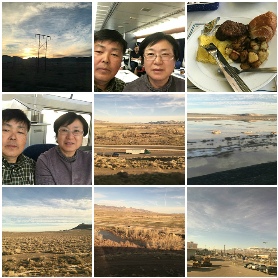
1. 일출 나무전주 2-3 아침식사
4. 돔카 5. I-80 하이웨이 6. 소금물
7. 내염 관목들 8.트러키 강 9.리노
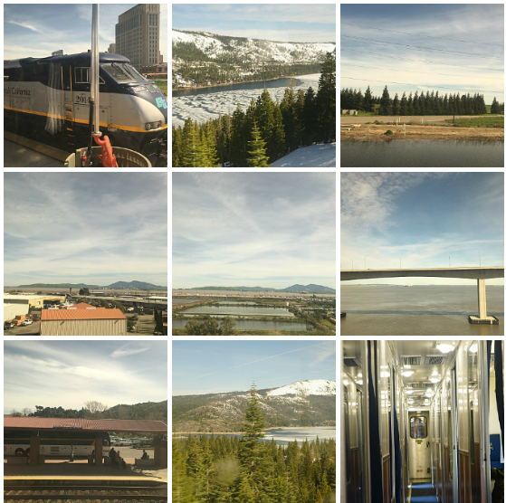
1. 세크라멘토 역 2. Donner Lake 3.캘리포니아 엘미라 근처
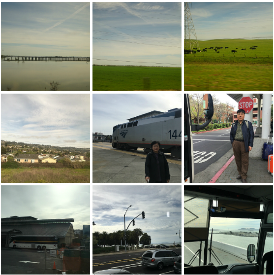
7. Martinez 역 8. 주변풍경 9. 암트랙 기차 내부
7. 에머리빌 역 8-9. 베이브릿지
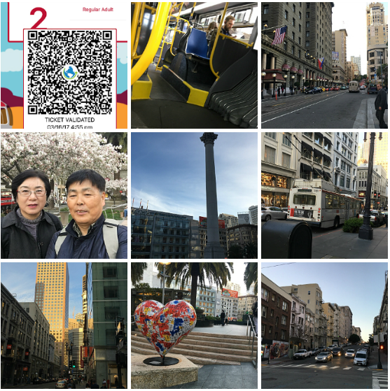
1. 스마트폰의 뮤니패스 2. 38번 버스 3. 유니온파크 앞
4-5, 유니온파크 6. 메이시스백화점
7. 쇼핑몰 Crocker Galleria 8.유니온파크의 하트 9. Geary Street
GRAND JUNCTION (1311 mi.) is located where the Gunnison and
Colorado Rivers join. Prior to 1921, this part of the Colorado River was
known as the Grand River--thus Grand Junction. The city is surrounded
by the mountains of the Colorado National Monument. Powderhorn
Ski Resort sits on the east side of the Grand Mesa, the blue mountain
to the east, which is one of the world’s largest flat top mountains. The
nearby Country Jam Ranch is a permanent music festival site that hosts
Country Jam that draws thousands of country music fans to the area
each year.
Mack (1330 mi.) After the California Zephyr passes through the last
town in Colorado, it turns southward, passes under I-70 and makes
its way back toward the Colorado River and Ruby Canyon, a popular
destination for rafting, which takes its name from the red sandstone
cliffs lining the Canyon walls. Erosion via wind and water has hewn
smooth textures and fascinating shapes in the striking red stone over
eons of time. The canyon runs for 25 miles through Colorado and Utah.
Colorado/Utah State Line
A sign marking the state line was painted by railroaders on the canyon
wall on the right.
About five miles after passing through Ruby Canyon we get our final
glimpse of the Colorado River on the left.
Thompson Springs (1390 mi.) In 1985 Thompson went back to the
future and re-adopted the town’s original name, Thompson Springs. The
area south of town is rich in uranium deposits.
GREEN RIVER (1417 mi.) sits at 4,078 ft. elevation, the lowest
point between Salt Lake City and Denver. It is a popular spot for
“freeride” mountain biking. On the left are Marvine and Thousand Lake
Mountains. Remain on the alert for herds of the apocryphal jackalope,
hare-like antlered creatures said to appear without warning in these
parts.
Price (1481 mi.) may have a population of only 8,400, but it’s the
largest town since leaving Grand Junction. It is home to the Utah State
University-College of Eastern Utah and a large prehistoric museum. The
Book Cliffs on the right extend back into Colorado and offer evidence
that everything to the south of here was once under water.
HELPER (1488 mi.) The town name comes from the railroading
activity that took place here for years--adding “helper” engines to
westbound freight trains so they can get up the Wasatch Plateau
to Soldier Summit. Mining has always been the other key economic
activity here, and there is said to be enough local coal to meet the
country’s needs for almost three centuries. It’s not surprising then that
the city hosts the Western Mining and Railroad Museum.
Castle Gate (1492 mi.) is a former mining town dismantled in 1974.
Its rock formation seems to open like a giant castle gate as the train
approaches and closes as it leaves. Butch Cassidy is said to have held
up the Pleasant Valley Coal Company here for $7,000 in gold in 1897.
From here to Soldier Summit the California Zephyr will follow the Price
River up the Wasatch Range.
Soldier Summit (1513 mi.) at 7,000 feet elevation is named for the civil
war soldiers buried here in 1860. This area is a favorite train watching
spot for railfans, so don’t be surprised if you see them with cameras
ready to photograph the California Zephyr as we reach the top of the
Wasatch Plateau. After we pass the summit, we’ll start heading down
thru Spanish Fork Canyon and negotiate a series of switchbacks called
the Gilluly Loops.
Thistle (1542 mi.) is a recent ghost town, caused by a 1983 mudslide
that moved part of a mountain, blocked two creeks and formed an
earthen dam. Water from the creeks backed up and flooded the town.
The landslide also closed the railroad for months. Thistle’s remains,
a few rooftops, can be seen on the left side of the train after emerging
from the tunnel which was part of the relocation of the railroad
following the disaster. The incident was the first ever federal disaster
area declared in the state of Utah.
PROVO (1563 mi.), the third largest city in Utah, hosts Brigham
Young University and the largest missionary training center for the
Mormon Church. The Wasatch Range “Y Mountain” towers over the
city; the letter was built to commemorate the university. Provo is home
to software company Novell, Inc., which has helped make technology
and software an important industry in the Utah Valley area. Provo is
also home to the Osmond family of entertainers. Stephen Covey, the
famous author of The 7 Habits of Highly Effective People, also resides
in Provo. Just outside of Provo is the entrance to the Uinta and Manti-
La Sal National Forests.
SALT LAKE CITY (1608 mi.) is the world headquarters of the
Church of Jesus Christ of Latter Day Saints, founded in 1847 by a
group of Mormon pioneers led by Brigham Young. Temple Square in
the heart of downtown houses the six-towered Mormon Temple. The
church’s world renowned genealogical research facility brings people
from all over the world researching their family tree. Mining and
the first transcontinental railroad brought initial economic growth.
Today’s economy is primarily service oriented around government,
transportation, technology, utilities and professional and business
services. In recent years the area has developed both a light rail system
(TRAX) for the immediate Salt Lake City area, and a commuter rail
system (Front Runner) that links the city to Ogden on the north and
Provo on the south. The valley in which the city lies is considered one
of the safest and most attractive natural settings in North America.
Utah/Nevada State Line
Change your watch from Mountain to Pacific Time: one hour back if
westbound, one hour ahead if eastbound.
ELKO (1871 mi.) was founded in 1869 as a town along the just
completed transcontinental railroad. Once dubbed “the last real cow
town in the American West,” the city still is a ranching center with
western roots, but now also relies on tourism since the opening of the
Red Lion Casino. The town hosts the National Cowboy Poetry Gathering
festival each January and the National Basque Festival every July. A
stuffed 10-foot tall polar bear graces the Commercial Casino.
WINNEMUCCA (2013 mi.) You know you’re in a western town when
October brings the National Senior Pro Rodeo Finals, the Ranch Hand
Rodeo Weekend is held in February, the Winnemucca Mule show in
June, and barrel races in August. And if western events are not what
you’re looking for, try the Run-A-Mucca Motorcycle Rally in May.
Indeed, the town’s motto may hit the nail on the head: “Winnemucca,
NV. There’s more than meets the eye.”
Lovelock (2086 mi.) The area around this town was considered the
most difficult of the entire journey by the Pony Express riders and
by those who traveled west by covered wagon in the days before
the transcontinental railroad. The Humboldt River which meanders
across the desert between the Trinity Mountains on the right and the
Humboldt Range on the left, would disappear into the sand leaving
water that was full of minerals and barely drinkable. Lovelock’s
economy today is largely agricultural, producing bananas and alfalfa.
Fernley (2154 mi.) The first sign that you’ve left the open spaces of
the west and are nearing the Reno/Sparks metro area is this suburb
of new homes on the left. This town is best known as the home of a
750,000 square foot distribution center for Amazon.com. From here
the California Zephyr begins following the Truckee River.
Sparks (2199 mi.) is, for all practical purposes, a twin city with Reno.
The Southern Pacific built a switching yard here in 1904 which
spurred population growth. A number of casinos also contributed to
Sparks’ growth and then in the 1970s favorable taxation resulted
in an expansion of warehousing and distribution industry. The most
significant Sparks casino, the Nugget, is on the right side.
RENO (2202 mi.) “The Biggest Little City in the World” began as a
modest gold mining service settlement which grew after the discovery
of silver in 1859. Tailor Jacob Davis came to Reno in 1868 and began
to use rivets to secure the pockets of his men’s trousers. Worried that
the idea would be copied, he contacted Levi Strauss to apply and pay
for a patent, which was granted in 1873. As mining waned in the
1900s, Nevada legalized casino gambling in 1931 and passed liberal
divorce laws, both boons for Reno. An antique car collection and major
entertainers entice gamblers to Reno today, along with special events
all year.
Verdi (2213 mi.) The site of the first train robbery in the West in 1870.
There is now a hydroelectric generator powered by a water flume – a
wooden trough that collects water at four sites in the mountains.
Nevada/California State Line (2217 mi.)
The state line is indicated by a small marker on your right.
Floriston (2223 mi.) Here rainbow trout, brook trout and German
browns travel up and down the Truckee River to and from Verdi by
means of a fish ladder.
Boca (2229 mi.) in its heyday produced lumber, but the town was
dismantled in the 1920s after the sawmill closed. All that remains are
a bridge and a dam on the right. The oddly shaped rock formations
resembling castle spires that you now see were developed through
erosion by wind and water and are known as “Hoodoo Pillars.”
TRUCKEE (2237 mi.) was named after a Paiute chief, Trukizo, father
of Chief Winnemucca. The first settlers encountered his tribe with the
friendly chief yelling “Tro-kay” at them, the Paiute word for “hello.”
Note the renovated former Bank of America on the left side of the train,
now “The Bar of America,” a popular downtown restaurant.
Stanford Flats (2243 mi.) We now cross back and forth across a series
of ascending plateaus as we begin the climb over Donner Pass to the
peak of the Sierras. Below is a panoramic view of the Truckee Basin.
Donner Lake (2245 mi.) on the right side of the train is where the
famed Donner Party, traveling west from Illinois, was stranded during
the winter of 1846-47. Some of the party of 87 resorted to cannibalism;
only 48 survived. After passing the lake, the California Zephyr passes
through a series of snow sheds that protect the track from being
blocked by the more than 30 feet of snow that falls in the typical
winter.
Mt. Judah (2248 mi.) We enter a tunnel through Mt. Judah some 7,000
feet above sea level, the peak point of our climb across the Sierras.
When we emerge, a ski lift from the adjacent Sugar Bowl Ski Resort
carries skiers over the track. The resort closed during World War II
for fear the Germans might blow up the tunnel and block this key
transcontinental rail route.
Norden (2252 mi.) was once the site of a Southern Pacific turntable and
maintenance point. It is marked by another snow shed.
Soda Springs (2255 mi.) As we reach Lake Van Norden on the left,
watch for Castle Peak on the right, a mountain with a rock formation
that looks like a castle on top. After Lake Van Norden is the Soda
Springs Ski Resort on the left. About 12 miles west of here is where
the Southern Pacific’s City of San Francisco streamliner, with 226
passengers aboard, got stuck for three days in a raging blizzard in
1952.
Emigrant Gap (2273 mi.) As we cross Interstate 80, look for a gap in
the ridge on the California Trail as it crosses the Sierra Nevada, west of
Donner Pass. The cliffs here are so steep that 1840’s pioneers crossing
to California were said to have lowered their wagons on ropes in order
to continue.
American River Canyon (2279 mi.) on the left side of the train is the
valley of the North Folk of the American River, located 1,500 to 2,000
feet below track level.
Cape Horn (2298 mi.) is a rocky bluff on the left side of the train some
1,500 feet above the American River. The slope from here down to
Colfax is the steepest on the Zephyr’s route. In this direction we’re
going the easy way--downhill as we complete our crossing of the
Sierras.
COLFAX (2301 mi.) was named for Schuyler Colfax, seventeenth Vice
President of the United States under the Ulysses S. Grant administration
between 1869 and 1873. A statue at the station showing a prospector
panning for gold during the Gold Rush days of the 1850s is featured
immediately off Main Street, a charming section of town that can be
seen on the right.
Auburn (2319 mi.) This is the heart of “Gold Rush” country. Just south
of town is Sutter’s Mill, where gold was discovered setting off an influx
of fortune seeking “49ers” (not the football variety) in the mid-1800s.
Claude Chana, a young Frenchman who had come by wagon train to
California, is said to have panned for gold and made his discovery
on May 16, 1848, in what became known as the Auburn Ravine. A
45-ton statue commemorating the event stands downtown. (James
Wilson Marshall’s discovery five months earlier on the American River
had set the stage for the gold rush. Forced off of his own land, he
sadly never profited from his discovery.) Several museums including
the Gold County Museum, Bernhard Museum and the Placer County
(Courthouse) Museum will tell you everything you ever wanted to know
about the Gold Rush, except where to find your own gold! The Amtrak
Auburn station is the easternmost terminus for the Capitol Corridor®
trains.
ROSEVILLE (2336 mi.) Settled by prospectors who had come to
California looking for gold, the town was originally a stagecoach
station but soon became a stop on the transcontinental railroad. In
the 1900s the Southern Pacific opened a major switchyard here which
turned Roseville into a rail town. Now part of the Union Pacific, we’ll
pass those yards after we leave the station. Today the city features a
diverse array of businesses, including one of the largest auto malls in
the U.S. Like many California cities it actively encourages transportation
alternatives to the automobile and now offers residents over 100 miles
of bicycle routes to get around.
SACRAMENTO (2353 mi.) was first settled in 1839. The city grew
significantly during the California Gold Rush, and in 1854 became
California’s capital. Sacramento was the western terminus for the Pony
Express, and was the starting point for eastbound construction to meet
the westbound track of the first transcontinental railroad at Promontory
Summit, Utah, in 1869. Sacramento State University is located here.
The city is home to the Sacramento Kings of the National Basketball
Association, and the Sacramento River Cats, a farm club of the
American League’s Oakland Athletics and one of the most successful
minor league baseball franchises.
California Zephyr Route Guide 9
Sacramento is at the confluence of the American River that we cross
prior to arrival, and the Sacramento River that we cross after departing.
We pass “Old Town” and the California State Railroad Museum on the
left after departing.
The station stop in Sacramento also serves the routes of the Amtrak
Capitol Corridor and Coast Starlight®.
DAVIS (2367 mi.) The long, low trestle we cross marks the “Yolo
Bypass”, a flood plain meant to divert flood waters away from
Sacramento. The 1913 adobe-style Davis station is an historic
landmark. This city is home to UC Davis, the largest campus in the
University of California system that in 2012 was ranked as the
“greenest” college campus in the U.S. by the Sierra Club magazine.
Rather than cars, 20,000 bicycles are the primary transportation mode
to, from and around campus. Indeed the motto of the City of Davis is
“Most Bicycle-Friendly Town in the World.”
Suisun Bay (2408 mi.) (Pronounced “soo-soon”) The “Mothball Fleet,”
consisting of World War II ships that have been stored for years, can be
seen off to the left as our train crosses the Carquinez Strait Bridge. The
large peak to the left is Mount Diablo (3,849 feet).
MARTINEZ (2411 mi.) From a trading post in 1849 to a flourishing
town in 1876, Martinez became a hub for the gold and shipping
industries. Although there are many competing claims, the town likes to
claim the invention of the martini; a plaque commemorating the event
is on a downtown corner. The most prominent Martinez native was Joe
DiMaggio, a local legend with the Pacific Coast League
San Francisco Seals before going on to baseball stardom with the New
York YankeesTM. (Younger readers of this route guide may recognize him
better as pitchman for “Mr. Coffee®.”) Martinez is the transfer point to
the Amtrak San Joaquin®.
The train skirts the shore of San Pablo Bay and then the San Francisco
Bay as we cover the final miles of our journey. The Bay Area Rapid
Transit (BART) trains can be seen on the left as we approach the next
to last station, RICHMOND (2430 mi.). Passing through Berkeley
(2436 mi.), the San Francisco skyline and Golden Gate Bridge can be
seen to the right across the bay.
EMERYVILLE (2438 mi.) is a small city of less than one square
mile located just north of the San Francisco-Oakland Bay Bridge, and
the end of the rail trip across the west. Major redevelopment in the
1980s and 1990s transformed this former industrial city into a mixed
use urban center with retail, entertainment and business centers, as
well as condominiums, parks and recreation trails. It’s home to Pixar®
Animation Studios and several biotech and software companies.
At Emeryville, passengers en route to San Francisco will board Amtrak
Thruway buses that operate to several stops in San Francisco. The bus
crosses the San Francisco bay on the San Francisco/Oakland Bay Bridge
which spans 8.4 miles some 200 feet above the water. Opened in 1936,
it carries approximately 280,000 vehicles per day. Watch for spectacular
views of San Francisco, Alcatraz Island and the Golden Gate Bridge.
Connecting the two halves of the bridge is the 539-ft. long Yerba Buena
Tunnel, the largest diameter tunnel in the world in 1936. The bridge
underwent major repairs and retrofitting after it was damaged in the
Loma Prieta (World Series) Earthquake in 1989.
SAN FRANCISCO (2447 mi.) Almost everybody who visits San
Francisco, the City by the Bay, is captured by its charms. The city grew
25-fold in 1849 after the discovery of gold at Sutter’s Mill the year
before, and has just kept growing and becoming more attractive. Today,
this popular international tourist destination is renowned for its steep
hills, famous landmarks, Alcatraz Island, Coit Tower, cable cars and
Chinatown as well as for its diverse cosmopolitan population lending
unmatched charm and character to the city. While early entrepreneurs
capitalized on gold wealth to benefit banking, railroads and trade, the
modern era saw the rise of the “Beat” and “Hippie” generations that
crystallized the progressive political nature of the population unlike
elsewhere in the U.S. Its world famous galleries, restaurants and shops
share top billing with Fisherman’s Wharf and the financial district to
lure vacation travelers from all over the globe. In the city where Tony
Bennett left his heart, small businesses with fewer than ten employees
make up 85 percent of city establishments. And in a city where the
49ers won five consecutive Super Bowls, its residents have been judged
the fittest in the U.S.
Thanks for traveling here on the Amtrak California Zephyr.